APPROX DISTANCE: 1 MILE, UTILIZING GLEN MEADOW SLUICE, CLEMENTINE WASH, AND FUZZBOTTOM BRAKE TRAIL
#1 - PEABODY RIVER
The Peabody originates about 2 ½ miles south of here, on the eastern flank of Mt. Washington. After flowing off the mountainside, it turns near the height of land in Pinkham Notch and begins its journey north, roughly parallelling Route 16. Thompson and Little Wildcat Brooks add to its size, as well as other small unnamed streams.
Beyond this point, the Peabody continues for another 8+ miles, joining the Androscoggin River in Gorham. The water eventually makes its way to the Atlantic via the Androscoggin and then the Kennebec River, emptying out below Phippsburg, Maine by Popham Beach.
There are a number of swimming holes on the Peabody, which have been attracting cold water bathers since the 1800s. Emerald Pool to the south and Third Hole to the north continue to be popular places to take a refreshing dip in this clear running mountain river.
Turn right at next intersection.

#2 - IS THE WATER POLLUTED?
No. The reddish brown slime you see is created by naturally occurring iron bacteria that “feed” on iron found in the soil and bedrock. Iron bacteria fulfill their energy requirements by oxidizing iron, creating rust colored deposits in the process. These bacteria occur anywhere oxygen, water and iron rich materials come into contact together. Iron is a common element in New Hampshire soils, and thus these slimy deposits occur throughout the state. While we advise always treating naturally occurring surface water before drinking it, no matter how clear, iron bacteria are harmless to humans.
#3 - FOREST VEGETATION
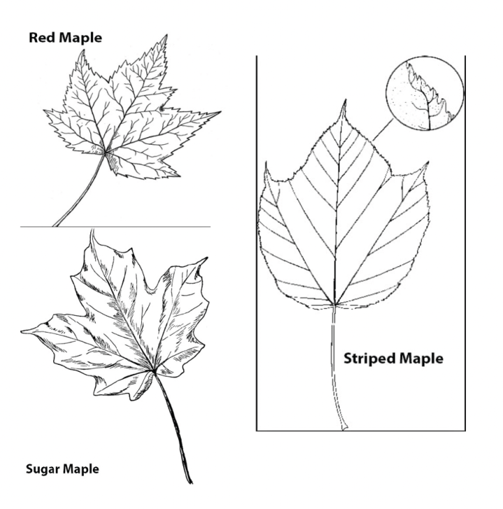
This forest has a number of tree species, most of them hardwoods with leaves that fall off in the autumn. There are three kinds of maples present here–sugar, red and striped, each having a slightly different leaf shape. During the fall, the leaves’ vibrant color changes create a spectacular show. Ash, cherry and birch trees are also present. At the south edge of this forest, a small collection of shade-intolerant quaking aspens persist. A water-loving paper birch is found along the edge of the river; a long branching yellow birch with narrow strips of peeling bark grows on the floodplain.
Most of the evergreen trees here are balsam fir. They have flat needles and smooth, gray bark. Often seen on the bark of young balsam fir trees are blisters that are filled with a resinous liquid. These trees are frequently found in damp woods and are the only type of fir found growing in the Northeast. There is a spruce tree visible from this path; on an island in the river a red spruce embraces a large rock with its roots, reaching up towards the sun through the break in the canopy.
#4 - NESTING BOXES
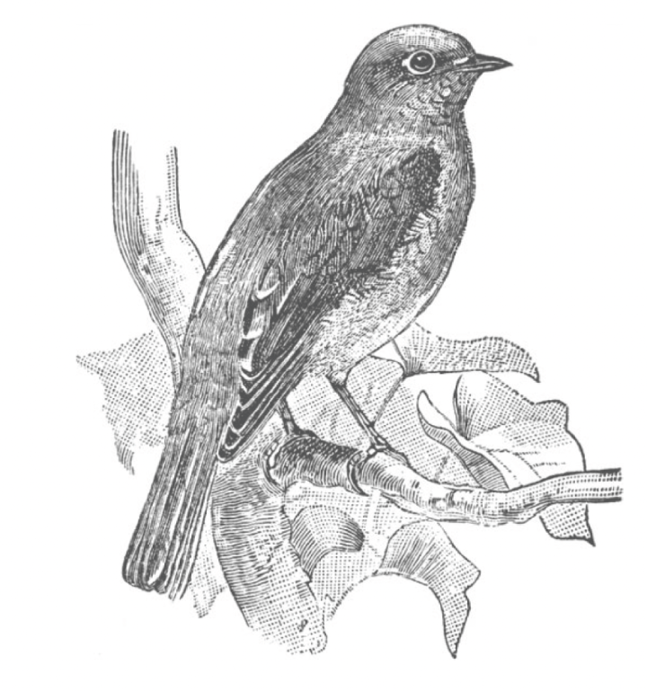
Along the fence from May to October you will notice of bird houses attached to the fence. They are placed annually to provide nesting cavities for eastern bluebirds. Bluebirds were once nearly eliminated from NH due lack of nest cavities. They have made an excellent comeback thanks to humans putting up nesting boxes.
Male eastern bluebirds have a blue head, back and with a rusty red breast and a white belly. The female grayish, with a faint blue tail and wings. Juveniles look similar to females with spots on their chests and blue markings. Bluebirds feed on insects and fruit.
Also commonly seen here are tree swallows, that also may make use of the nest boxes.
#5 - GREAT GULF
Look across the meadow to the view of the mountains. These are the northern Presidential mountains. This area was dramatically reshaped during the last glacial age, 12-25,000 years ago. This same era of glacial activity brought about the formation of Cape Cod and Martha’s Vineyard hundreds of miles away to our south.

Looking left to right, the features visible are Nelson Crag, the northeast shoulder of Mt. Washington, elevation 5635 ft; Mt. Jefferson, elev. 5716 ft; Jefferson Ravine; Mt. Adams, elev. 5799 ft; Madison Gulf; and Mt. Madison, elev. 5366 ft. The ridge extending towards you from Mt. Jefferson is known as Jefferson’s knee. The U-shaped valley that the mountainsides drop into is the Great Gulf. It is the Northeast’s largest glacial cirque, a landform resulting when a glacier excavates a v-shaped brook valley with a narrow floor and uniform slopes into a U-shape, with a broad, fairly flat floor and steep walls. This part of the White Mountain National Forest was established as a protected wilderness area in 1964. Hikers traveling the famous Appalachian Trail cross this region atop the open ridge linking these mountains. The Great Gulf Wilderness area encompasses about 5,500 acres.
Follow the trail as it goes around the field.
#6 - SIGNS OF PAST VISITORS
Over the course of its history, the Glen has seen various human activities, from farming to logging to hosting locals and tourists. Back in the 1970’s, during Auto Road General Manager Douglas Philbrook’s tenure, local boy scout troops camped here regularly. The abandoned outhouse you see in the woods is a leftover remnant from their annual stays.
#7 - WILDLAND EDGE
Here the field meets a swamp. Many different bird species can be found frequenting this wildland edge in spring, summer, and fall. The area provides their necessities: water, shelter, and a wide range of food choices from seeds to insects. This is a wonderful place to spot colorful warblers that arrive in the spring. An occasional hawk, which preys on smaller birds, will visit the area and quickly quiet the birds’ chatter.
Most of the brushy vegetation between the two habitats is speckled alder. Speckled alder grow in wet areas and can generate in poor soils due to their ability to use nitrogen from the air. By fixing the nitrogen in their root nodules, the alder enriches the soil for other plant species to develop.
The speckled alder is a favorite food of beavers. The water courses in this swamp have been dramatically shaped by beavers–their dam building creating new pathways, widening and deepening others. This can affect the trees that are present. The tall coniferous trees growing in the swamp are balsam fir. Balsam fir can tolerate wet soil, but living in too much water eventually leads to their death, explaining the presence of many dead trees within the swamp. Beavers are the only species besides man who can radically change their environment.
#8 - POND
If you wish to continue your walk, go straight here and find Glen Pond. This is a human-made pond, established in 1994 during the construction of this trail system. Many years it is stocked with rainbow and brook trout by fly fishing instructors who can provide lessons. The Great Glen paddling staff utilize the pond for the start of the Outdoor Center’s kayak classes.
The pond attracts animals and birds as well. Canada geese, mergansers, ducks, swallows and even cormorants have been spotted here, as have otters. Frogs followed by newly hatched tadpoles are common to see in the spring and early summer. The rare catch of an unstocked brown trout followed the flooding of the surrounding meadows by Hurricane Irene, the fish having been swept off course from the Peabody River.
More trails extend into the surrounding fields and forest of the Glen. Explore at your leisure, remembering to pause, look, listen, and absorb the beauty and peacefulness that visitors have come to enjoy since the 1800s.


